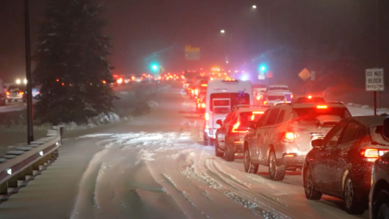
Hastings, Nebraska – Light snow and strong northeast winds are creating hazardous travel conditions across south central Nebraska today, particularly near Hastings and along the Interstate 80 corridor. Temperatures hovering near 22 degrees this morning, combined with wind gusts reaching 35 mph, are pushing wind chills below zero at times.
Forecasters warn that even minor snow accumulation could lead to reduced visibility and drifting snow across open highways, especially during the late afternoon and evening hours.
Incident Overview
Fine snowflakes have been sweeping across rural areas near Hastings since early morning, carried by persistent northeast winds. While total daytime snowfall is expected to remain under 1 inch, blowing snow could significantly impact drivers along Highway 281, I-80, and routes heading north toward Grand Island.
Officials emphasize that drifting snow can quickly accumulate across exposed stretches of roadway, particularly in open farmland areas where wind barriers are limited.
Timeline of Expected Conditions
Snow chances increase later in the day, mainly after 5 p.m., though patchy blowing snow may develop earlier this afternoon. Visibility could drop suddenly in brief bursts, creating localized whiteout conditions in open areas.
Tonight, snow chances rise before 9 p.m., with cloud cover gradually thinning late. Overnight lows are forecast to plunge to around 11 degrees, increasing the risk of refreezing.
Friday will bring slightly brighter conditions but continued cold temperatures. Highs are expected near 33 degrees, with a slight chance of lingering snow. Friday night temperatures will dip again to around 15 degrees, with the possibility of additional light snowfall.
Key Weather Facts
• Morning temperature: 22 degrees at Hastings Municipal Airport
• Wind gusts: Up to 35 mph
• Wind chills: Below 0 degrees at times
• Daytime snow totals: Under 1 inch
• Overnight low tonight: 11 degrees
• Friday high: 33 degrees
• Saturday high: 41 degrees
• Tuesday high: Near 63 degrees
Travel Impacts Along I-80
Blowing snow remains the primary concern for drivers traveling along Interstate 80 and surrounding highways. Even limited snowfall can be redistributed by strong winds, leading to slick patches and drifting across lanes.
Bridges, overpasses, and untreated rural roads will be especially vulnerable to flash freezing tonight as temperatures fall sharply. Any snow that partially melts during the day could refreeze quickly after sunset.
Drivers are advised to reduce speed, increase following distance, and remain alert for sudden visibility drops, particularly in open fields where wind speeds are strongest.
Public Safety Advisory
Local emergency management officials recommend that motorists carry winter emergency kits, including blankets, flashlights, water, and charged mobile phones. If you encounter sudden whiteout conditions:
Slow down gradually and avoid slamming on brakes.
Keep headlights on and maintain a safe distance from other vehicles.
If visibility drops to near zero, consider pulling off the roadway safely until conditions improve.
Wind chills below zero can also pose a risk to anyone stranded outdoors. Frostbite can develop quickly in these temperatures, especially on exposed skin.
Weekend Outlook and Warming Trend
Saturday will bring partial sunshine with highs near 41 degrees, followed by clear skies Saturday night and lows around 14 degrees. Sunday remains sunny but cold, with highs near 37 degrees.
By Monday, temperatures begin to moderate, reaching around 40 degrees under sunny skies. A more noticeable warm-up is expected midweek, with highs pushing toward 60 degrees by Tuesday, signaling a transition toward early spring-like conditions across south central Nebraska.
Five-Day Outlook – Hastings
Friday: Mostly cloudy, high near 33
Saturday: Mostly sunny, high near 41
Sunday: Sunny, high near 37
Monday: Sunny, high near 40
Tuesday: Partly sunny, high near 63
Conclusion
While snowfall amounts may remain relatively light, strong winds and subfreezing temperatures make today’s weather event significant for drivers across Hastings and the I-80 corridor. Blowing snow, drifting, and flash freezing tonight could create hazardous road conditions well into Friday morning.
Residents should remain cautious, monitor local forecasts, and prepare for rapidly changing visibility on rural highways.
Slow down, stay alert, and plan extra travel time. Share your experiences in the comments below.